Weather and Climate Interface
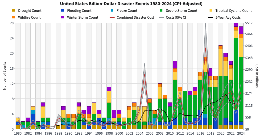
In the United States, the number of weather and climate disasters exceeding $1 billion (USD) in damages has risen markedly since 1980, reaching a record 28 events in 2023 (NOAA NCEI, 1980–2024). This rise reflects growing exposure and vulnerability as well as changes in the frequency of some extremes. Many of these disasters, from severe convective storms to flash floods, are driven by clouds and storms that develop over kilometers and hours, yet their frequency and intensity are shaped by larger-scale climate variability and long-term change.
The Weather–Climate Interface research explores how extreme weather events, particularly cloud and storm processes, develop from local atmospheric conditions and how their characteristics evolve in a changing climate.
By combining long-term satellite observations, field-campaign data, and convection-permitting regional climate simulations of current and future climates, this research connects storm-scale phenomena with broader climate variability. Recent work characterizes current and future convective storm modes over the contiguous United States using GPM observations and convection-permitting simulations. It also examines the climatology and storm types of heavy rainfall events in different climate regions, including South America and Taiwan, and investigates how diurnal and quasi-2-day variability organizes clouds over convectively active regions. Machine learning increasingly complements these physical approaches by helping bridge the gap between coarse-resolution climate models and storm-scale processes (see Machine Learning Application to Clouds and Storms).
Research topics include,
- Three-dimensional cloud and storm structures: identification and classification of convective storm modes from satellite observations and models.
- Mesoscale convective processes and life cycles: regional impacts over the United States, Taiwan, and South America, and their global patterns.
- Multiscale variability: diurnal and quasi-2-day cloud variations, and the modulation of mesoscale convective organization by convectively coupled equatorial waves.
- Extreme rainfall in complex terrain: storm types and environmental ingredients associated with heavy rainfall.
- Storms in a warming climate: changes in convective storm modes and populations in convection-permitting regional climate simulations.